Hurricane Ian Nears Category 5 Strength as It Begins Lashing Florida. Here Are the Latest Updates
Hurricane Ian, a Category 4 storm with winds of up to 155 mph, may make landfall in Florida Wednesday.
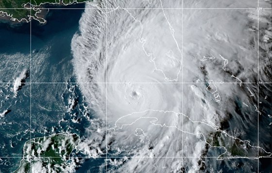
Hurricane Ian, a Category 4 storm, with winds of up to 155 mph, is approaching Category 5 strength and could make landfall in southwest Florida as one of the strongest storms ever to hit the continental U.S. Ian gained strength after striking Cuba on Tuesday.
It is already projected to be the costliest storm in U.S. history, affecting large swaths of Florida and reaching other parts of the Southeast; the storm will spawn “catastrophic wind damage,” flash flooding and torrential rainfall. Federal weather authorities announced that the storm could be “life threatening” and that everyone in the hurricane zone should promptly follow evacuation orders from local authorities.
[time-brightcove not-tgx=”true”]
Floridians have been preparing for Ian since Monday, especially around the Tampa Bay region where flights were pre-emptively canceled, evacuation orders were issued, and power was cut to mitigate equipment damage from the storm.
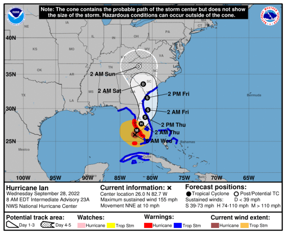
Scientists warn that climate change is helping to turbocharge storms like Ian, and that the warming world pushes storm intensity to grow, resulting in deadlier, more damaging storms. At 8 a.m. ET on Wednesday, the eye of the hurricane was just off the southwestern Florida coast near Fort Myers, but it’s projected to move further inland across the next three days.
Here’s what you need to know.
Where will Hurricane Ian hit?
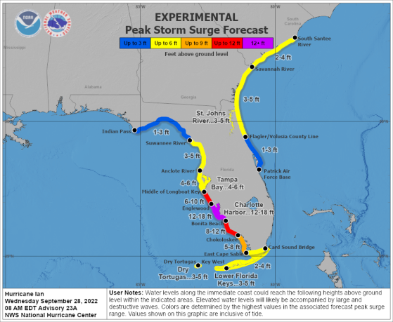
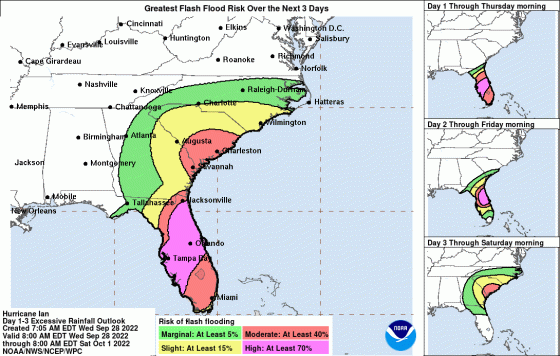
Ian is predicted to impact the entire state of Florida, focusing on the eastern and northwestern coasts, as well as Georgia and much of South Carolina. Most of the storm surge’s peak will be three to six-foot-high water above ground level along the coast, but Englewood, Bonita Beach, Charlotte Harbor, Longboat Key, Chokoloskee and the areas in between will be hit the hardest with seven to 16-foot surges.
Southwestern Florida, including Miami, won’t be affected as severely by rising seas because of the trajectory of the storm, but the entire state will suffer from high risks of flash flooding, a heightened rainfall forecast and dangerous winds.
The storm’s wind force is predicted to spread through all of Florida by Wednesday night and go on to move up through Georgia, South Carolina and North Carolina on Thursday and Friday.
Ian could be one of the strongest hurricanes to ever hit the U.S.
Ian, now a Category 4 storm, will bring heavy rainfall across Florida and storm surges up to 16 feet in some areas along the coast, according to the National Hurricane Center. To become a Category 5 hurricane, Ian only needs to reach 157 miles per hour.
The difference between Category 4 and 5 hurricanes is significant in terms of damage.The National Hurricane Center says that a high percentage of well-built framed homes, which can sustain damage caused by Category 3 wind and rainfall, are likely to be destroyed once a storm reaches Category 5 status. Much of the area hit directly by a Category 4 or 5 storm is likely to be uninhabitable for weeks, if not months.
“A storm of this magnitude will produce catastrophic flooding and life-threatening storm surge,” said Florida Gov. Ron DeSantis, in a press conference on Wednesday. “So this is going to be a nasty, nasty day, two days.”
The last Category 5 storm to make landfall in the U.S. was Hurricane Michael in 2018, which the National Oceanic and Atmospheric Administration (NOAA) labeled as the fourth strongest storm to hit the U.S. It caused $25 billion in damages, with the majority of impact occurring in the Gulf Coast of the Florida panhandle.
Chuck Watson, a disaster modeler with Enki Research, said Ian could cause nearly double the amount of damage that Hurricane Michael caused. He predicts economic loss could reach anywhere from $45 billion to $70 billion as approximately 75% of the state’s orange groves are under threat.
What areas are being evacuated?
The NOAA says storm surge inundation will reach 12 to 16 feet along the southwest Florida coastline from about Englewood to Bonita Beach. Residents have been encouraged to evacuate, as Gov. DeSantis noted in his press conference that the storm will likely make landfall in Charlotte County.
There are more than 10 counties with mandatory evacuation orders, though the governor noted that it is no longer safe to evacuate high-risk areas like Sarasota or Collier County. Residents who stayed behind are encouraged to stay in their homes and prepare, and those on the road are expected to find a place to stay in the more than 200 shelters in Southwest Florida.
Sunshine Skyway Bridge, along with other local bridges, have been closed due to strong winds.
The state’s response team and National guard have been deployed to help.